Groundwater Exploration in Michika Local Government Area of Adamawa State using Resistivity Method

International Journal of Earth Science and Geophysics
(ISSN: 2631-5033)
Volume 8, Issue 2
Research Article
DOI: 10.35840/2631-5033/7560

Article Formats
Groundwater Exploration in Michika Local Government Area of Adamawa State using Resistivity Method
Table of Content
Figures


Tables
Table 1: Models interpretation results.
References
- Oladejo OP, Sunmonu LA, Adagunodo TA (2015) Groundwater prospect in a typical precambrian basement complex using Karous-Hjelt and fraser filtering Techniques. J Ind Eng Res 1: 40-49.
- Akinrinade OJ, Adesina RB (2016) Hydrogeophysical investigation of groundwater potential and aquifer vulnerability prediction in Basement complex terrain - a case study from Akure, southwestern Nigeria. Materials and Geoenvironment 63: 55-66.
- Anudu GK, Onuba LN, Ufondu LS (2011) Geoelectrical sounding for groundwater exploration in the crystalline basement terrain around Onipe and adjoining areas, southwestern Nigeria. Journal of Applied Technology in Environment Sanitation 1: 343-354.
- Anomohanran O, Ofomola MO, Okocha FO (2017) Investigation of groundwater in parts of Ndokwa district in Nigeria using geophysical logging and electrical resistivity methods: Implications for groundwater exploration. J Afr Earth Sci 129: 108-116.
- Oladejo OP, Sunmonu LA, Ojoawo A, Adagunodo TA, Olafisoye ER (2013) Geophysical investigation for groundwater development at Oyo state housing estate Ogbomosho, Southwestern Nigeria. Res J Appl Sci Eng Technol 5: 1811-1815.
- Kasidi S, Ndatuwong LG (2017) Application of vertical electrical Sounding (VES) In delineating ground water potential in some part of Jalingo, Taraba State North Eastern Nigeria. International Journal for Research in Applied Science & Engineering Technology (IJRASET) 5: 588-566.
- Alabi AA, Bello R, Ogungbe AS, Oyerinde HO (2010) Determination of groundwater potential in Lagos State University, Ojo; using geoelectric methods (vertical electrical sounding and horizontal profiling). Rep Opin 2: 68-75.
- Al-Amri A (1996) The application of geoelectrical surveys in delineating. Groundwater in semiarid terrain, Case history from central Arabian Shield. M.E.R.C. Ain Shams Univ, Earth Sci Survey 10: 41-52.
- Wright EP (1992) The hydrogeology of crystalline basement aquifers in Africa. Geological Society, Special Publications, London, 268.
- Lazarus G Ndatuwong, Yadav GS (2014) Identifications of fractured zones in part of hard rock area of Sonebhadra District, U.P., India using integrated surface geophysical method for groundwater exploration. Arab J Geosci 7: 1781-1789.
- Hubbard SS (2011) Hydrogeophysics. Lawrence Berkeley National Laboratory, Berkeley.
- Carter OJ, Baber W, Tait EA (1963) The Geology of part of Adamawa, Bauchi and Borno Provinces in Northeastern Nigeria. Geol Survey Bulletin 30.
- Daral H (1991) Michika master plan draft, final report. Ministry of Land and Survey, Gongola State, 1.
- David LM, Ofrey O (1989) An indirect method of estimating ground water level in basement complex regolith. Water resources 1: 34-41.
- Osemeikhian JEA, Asokhia MB (1994) Applied geophysics for engineers and geologists. (1 st edn), Samtos services Ltd., Lagos.
- Louis I, Karantonis G, Voulgaris N, Lois F (2004) Geophysical methods in the determination of aquifer parameters: The case of Mornos river delta, Greece. Res J Chem Environ 18: 41-49.
- De Lima OAL, Niwas S (2000) Estimation of hydraulic parameters of shaly sandstone aquifers from geological measurements. J Hydrol 235: 12-26.
- Khalil MH (2006) Geoelectric resistivity sounding for delineating salt water intrusion in the Abu Zanima area, west Sinai, Egypt. J Geophys Eng 3: 243-251.
- Nur A, Ayuni KN (2011) Hydro-geophysical study of michika and environs, northeast Nigeria. International Journal of the Physical Sciences 6: 7816-7827.
- Mallam A, Ajayi CO (2000) Resistivity method for groundwater investigation in sedimentary area. Nig J of Physics 12: 34-38.
- Alile MO, Jegede SL, Ehigiator OM (2008) Underground water exploration using electrical resistivity method in Edo State, Nigeria. Asian Journal of Earth Sciences 1: 38-42.
- Interprex Limited (1998) Resix, scientific software program.
- Jones MT (1985) The weathered zone aquifers of the basement complex area of Africa. Q J Eng Geol 27: 63-69.
- Nwankwo LI, Olasehinde PI, Babatunde EB (2004) The use of electrical resistivity pseudosection in elucidation the geology of an east-west profile in the basement complex terrain of Ilorin, West-Central, Nigeria. Nig J Pure Appl Sci 19: 1676-1682.
- Oyodele KF, Ogagarue DO, Esse O (2011) Groundwater potential evaluation using surface geophysics at Oru-Imope, South-Western Nigeria. European Journal of Scientific Research 63: 515-522.
- Obiabunmo OC, Umego MN, Obiekezie TN, Chinwuko AI (2014) Application of electrical resistivity method for groundwater exploration in Oba and environs, Anambra state, Nigeria. Adv Phys Theor Appl 37: 19-29.
Author Details
Lazarus G Ndatuwong* and Habila Mathew
Department of Pure and Applied Physics, Adamawa State University Mubi, Adamawa State, Nigeria
Corresponding author
Lazarus G Ndatuwong, Department of Pure and Applied Physics, Adamawa State University Mubi, Adamawa State, Nigeria.
Accepted: November 10, 2022 | Published Online: November 12, 2022
Citation: Ndatuwong LG, Mathew H (2022) Groundwater Exploration in Michika Local Government Area of Adamawa State using Resistivity Method. Int J Earth Sci Geophys 8:060.
Copyright: © 2022 Ndatuwong and Mathew. This This is an open-access article distributed under the terms of the Creative Commons Attribution License, which permits unrestricted use, distribution, and reproduction in any medium, provided the original author and source are credited.
Abstract
A geophysical investigation involving the electrical resistivity method using Schlumberger electrode array was conducted around some selected residential areas of Michika local government, a basement terrain of northeastern Nigeria. Twelve (12) Vertical Electrical Sounding (VES) was carried out across the study area using a maximum half-electrode current separation of 100m. The study was carried out with a view to explore groundwater resource in the study area. The interpreted data was able to identify different subsurface geoelectric layers, the depth to the possible aquifer unit, and locate possible and suitable sites for productive boreholes in the study area. The inferred lithologies includes: sandstone, clay/overburden, laterite, clay soil, weathered basement, fractured and fresh basement. The result revealed two types of aquifers in the study area; the weathered basement and sandstones formation. VES 01, 02, 05, 06 and 07 has the weathered basement as their aquifer, while VES 03, 08, 09, 11 and 12 are made up of sandstones aquifer. VES 04 and 10 has clay layers as aquitard at their locations. The aquifers in the study area are suitable for hand dug wells and boreholes depending on their thicknesses.
Keywords
Aquifer, Resistivity, Schlumberger array, Groundwater, Vertical electrical sounding (VES)
Introduction
Water is described as the most indispensable natural resource on which life depends. It can be obtained from the troposphere as rain, surface flow as rivers and streams, and subsurface flow as groundwater [1-4]. Water located beneath the ground surface in soil pore spaces and in the fractures of lithologic formations is referred to as ground water; it is often utilized for agricultural, municipal and industrial purpose by constructing and operating extraction wells and widely used as a source of drinking supply and irrigation [5]. Its occurrence and distribution greatly vary according to the local as well as regional geology, hydrogeologic setting and to an extent the nature of human activities on the land. Groundwater occurrence in any region of the world is largely dependent on the nature and type of aquifer in such environment. This is because the nature and type of aquifer determines the quantity of groundwater that can be abstracted in a particular area to support her population [6].
A unit of rock or an unconsolidated deposit is called an aquifer when it can yield a usable quantity of water [7,8]. In basement complex setting such as the present study area, the geological structures normally encountered is characterized by the existence of crystalline bedrock overlain by a weathered overburden of variable thickness. Hydrogeologically, the weathered material, which constitutes the overburden, has high porosity and contains a significant amount of water, which serves as a good aquifer. The bedrock, on the other hand, is fresh but frequently fractured, presenting high permeability, which can also constitute a good aquifer in such a geologic setting. According to [9], Basement aquifers are developed within the weathered and fractured bed rock of crystalline rocks of intrusive or metamorphic origin which are mainly of Precambrian age.
Geophysical survey has played a vital role for groundwater exploration for many years. It is used to measure the physical properties of the subsurface, specifically related to the position of water and its quality, and the position and properties of geological units. Depending upon the scale of operation, geophysical surveys help to delineate regional hydrological features or pinpoint locations for drilling boreholes. It also has an advantage of providing spatial extensive information about subsurface in a minimal invasive manner [10].
The resistivity method is the most popular of all the geophysical methods as far as groundwater exploration is concerned. The method is based on the principle that electrical resistivity of a geological formation is dependent upon the material as well as upon porosity and water content of the formation [11].
It employs a phenomenon which makes the delineation and fluid content determination of various subsurface geologic units possible by analysing their electrical resistance response. Since there exists a close relationship between the electrical conductivity and some hydrogeological properties of an aquifer system, the electrical resistivity method has widely been used for quantitative estimation of water transmitting properties of aquifers, aquifer zone delineation and evaluation of the geophysical properties of the aquifer zone in several locations [12-14]. The aim of this work is the application of the electrical resistivity method to identify different subsurface geoelectric layers and locate possible and suitable site for productive boreholes in the study area.
Hydrogeology of the Study Area
The area is located within the eastern province of the basement complex of north-eastern Nigeria, mostrocks found within this location belong to the older granites of the Pan African Orogeny. The granitic rocks have undergone complete weathering leading to unconsolidated weathered overburden consisting of sands, clays and laterite. According to [15], the basement complex of the eastern province is divided into the Mandara mountain, Alantika mountain, Shebshi mountain and the Adamawa Massif.
Groundwater in general originate as surface water, but their occurrence and distribution are controlled by geologic factors such as lithology, texture of the rock and climatic factors such as rainfall. There are many rivers that originate from the mountains and generally flow towards west and northwest of the study area. Some of the rivers include River Rafin Wantse, Yedseram, and Rafin Nanda. The rocks aid in the formation of dendritic pattern of drainage network [16]. The plain soils are alternating bands of light gravel and dark loamy to clay soils. The valleys that drained the rivers have alluvial flood plains comprising mainly of coarse quartzitic materials. The area is underlain by crystalline basement complex, where the occurrence of groundwater is due largely to the development of secondary porosity and permeability by weathering and/or fracturing of the parent rocks [17] (Figure 1).
Materials and Method
Instrument used during the survey is ABEM Terrameter SAS 1000. This instrument measures and displays the resistance of the subsurface averaged over a number of cycles (two cycles for the purpose of this study). This continues until the operator is satisfied with the stability of the result. Other accessories used include; conducting cables, winches, crocodile clip, metal electrodes, measuring tape, hammer and a DC battery.
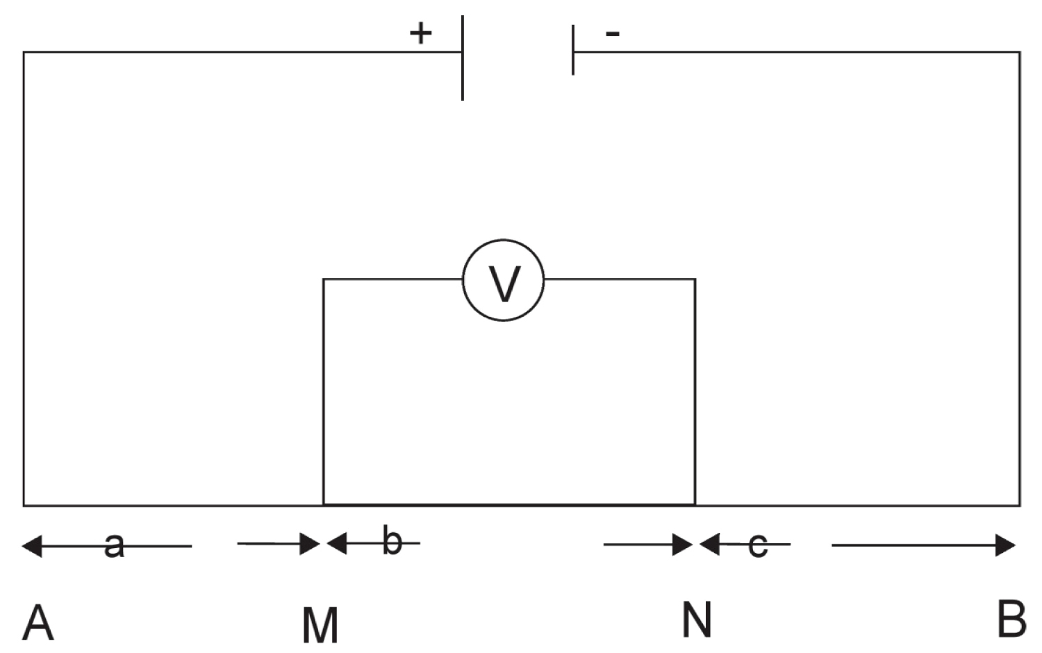
In this work a total of twelve (12) Vertical Electrical Sounding (VES) point were occupied using the Schlumberger electrode configuration. This configuration is mostly used as it provides subsurface information considering the depth of penetration which ranges between 1/3 and 1/4 of the total current electrode separation [18-20]. It involves the use of a pair of current electrodes and a pair of potential electrodes to measure the resultant potential difference within the subsurface. In the Schlumberger electrode configuration, four electrodes are placed at position A, M, N&B in a straight line on the earth's surface as in Figure 2. Electric currents are introduced into the ground by means of two current electrodes C1 and C2 placed at points A and B respectively, while the resulting potential is measured at the surface with the help of the survey instrument via the second pair of the electrodes P1 and P2 placed at points M and N respectively. Deviations from the pattern of potential differences expected from homogenous ground provide information on the form and electrical properties of the subsurface inhomogeneities.
Data Acquisition
A half-current electrode spacing (AB/2) that ranges from 1 to 100 m, while the half-potential electrode spacing (MN/2) ranges from 0.5 to 3 m was used in this work. The survey started at a short distance of AB/2, which is then increased progressively as the survey continued. At a certain point, the potential distance MN has to be increased especially when it becomes too small to give reliable readings of resistance [2,21]. However, the condition of AB ≥ 5MN has to be fulfilled. Data are obtained by increasing the electrode spacing linearly about a central position whose vertical resistivity variation is sought.
During data acquisition the electrodes were connected appropriately to their respective terminals on the Terrameter through cables and hammered into the earth to make good contact with the earth. During the process, the instrument transmits direct current into the earth subsurface through the pair of steel current electrodes, while the established subsurface potential difference across the subsurface under investigation was measured by the Terrameter through the steel potential electrodes. For each sounding, the measured resistance, R values obtained from different conducting horizons was converted to apparent resistivity values by taking the product of the resistance as measured by the Terrameter and the geometrical factor (K); a parameter which is dependent on the potential and current electrode arrangement. The Terrameter computes and displays a mean digital value of the apparent resistivity of the subsurface under investigation using;
Where
ρa is apparent resistivity, K is Geometric Factor, V is Voltage, I is Current, R is Resistance, AB is the Current electrode separation and MN is potential electrode separation.
Interpretation Procedure
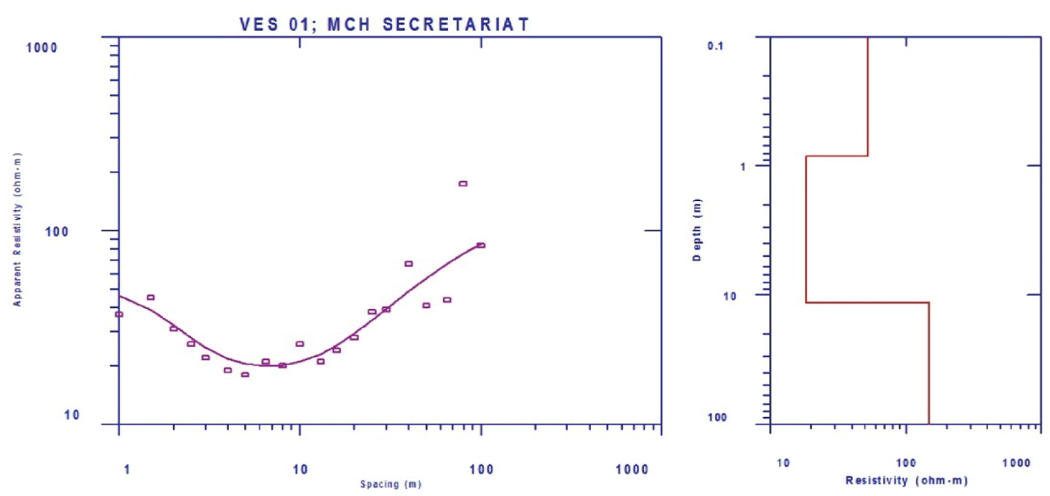
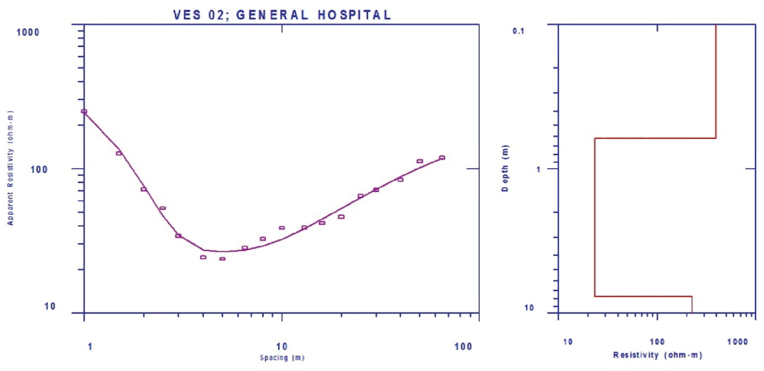
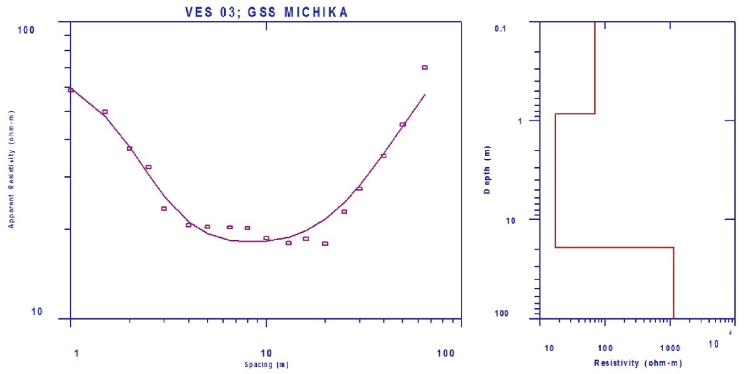
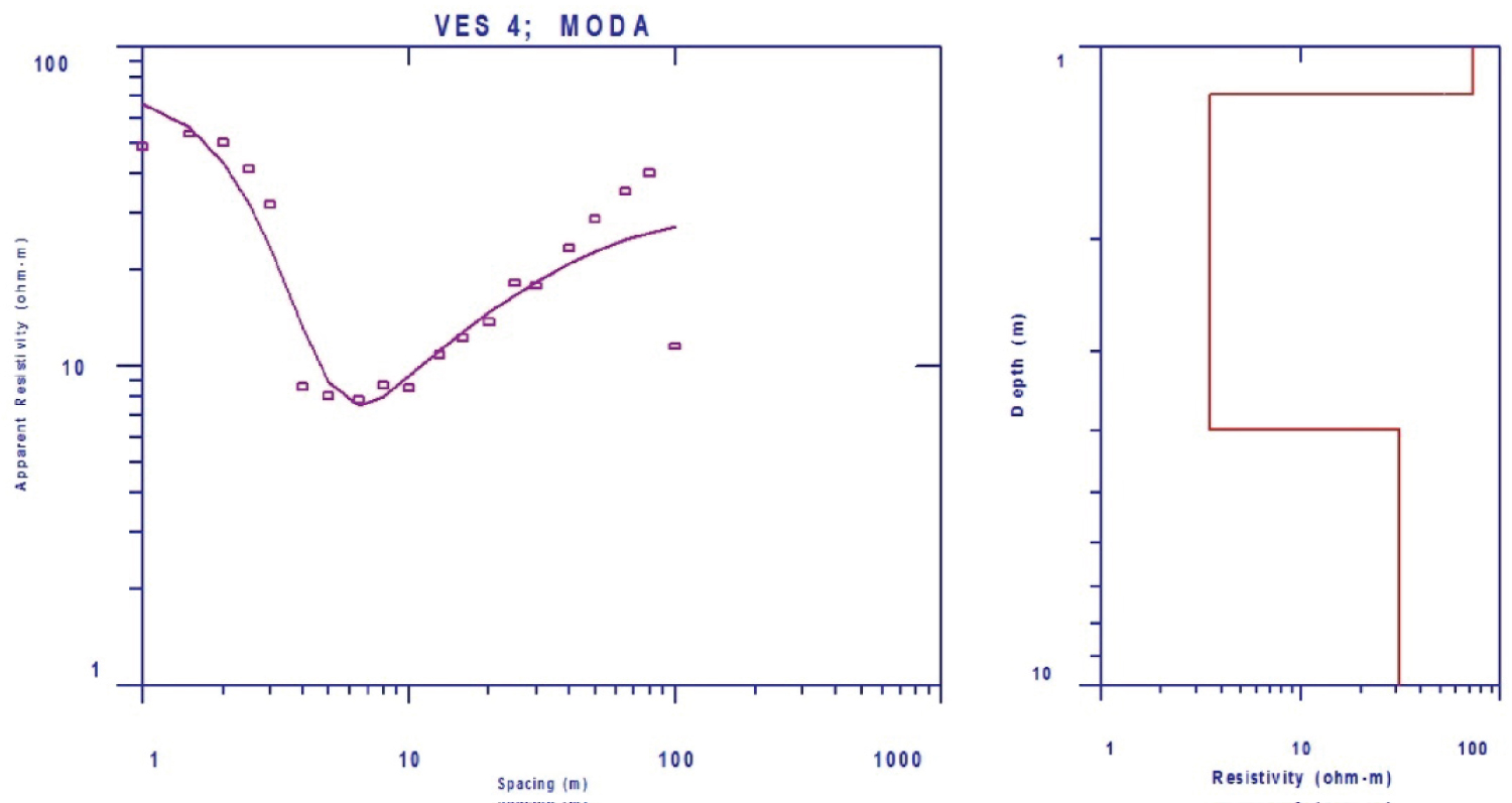
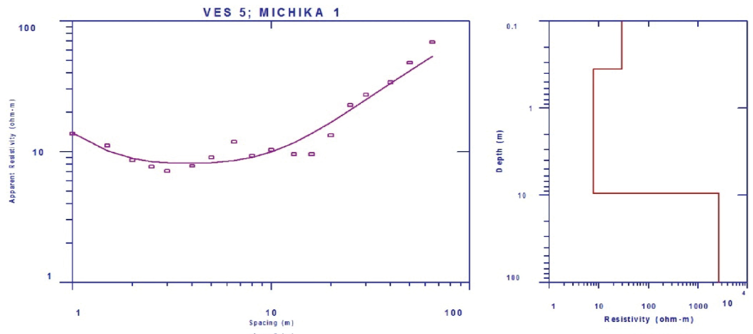
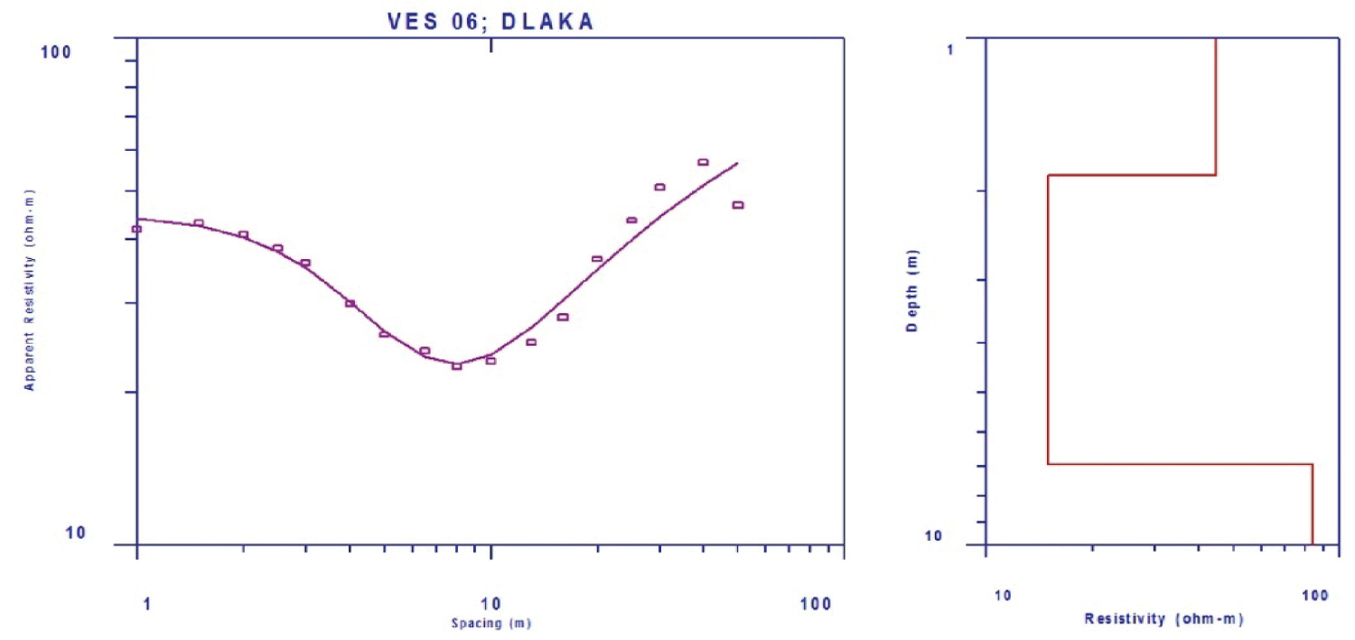
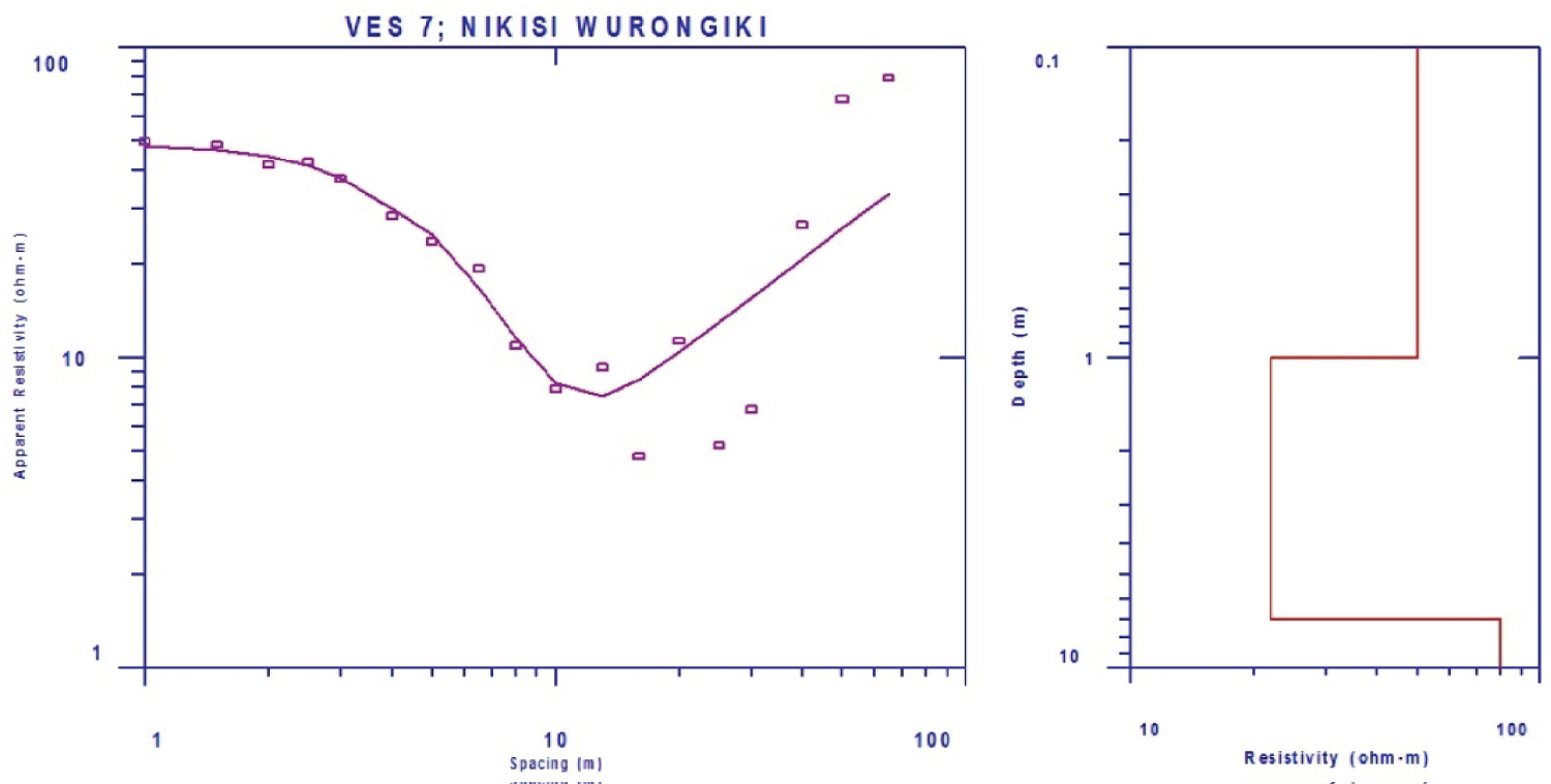
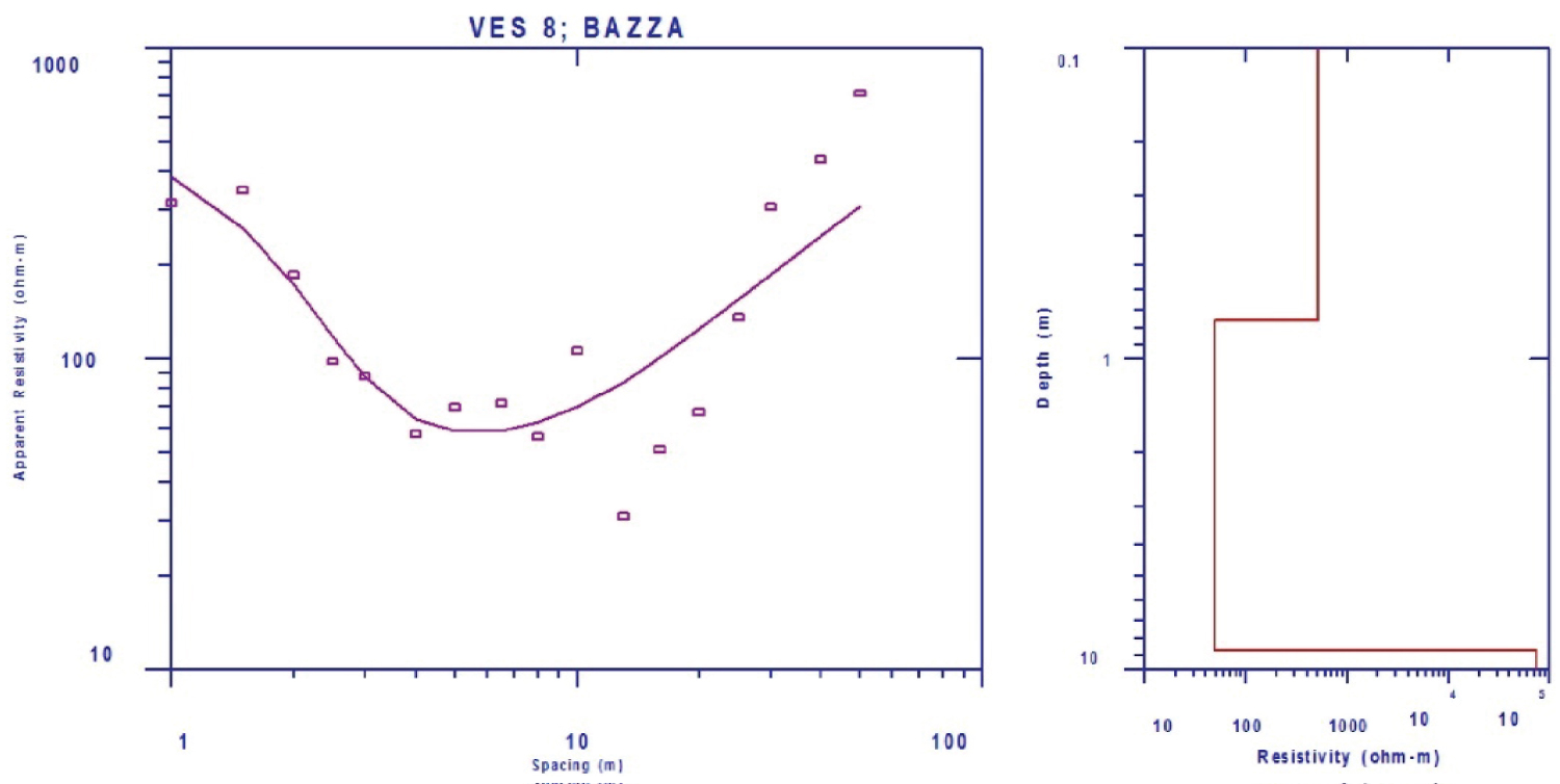
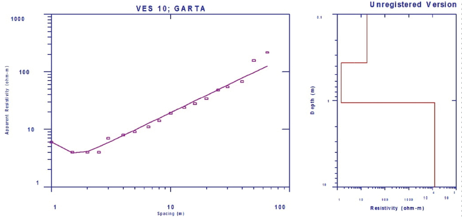
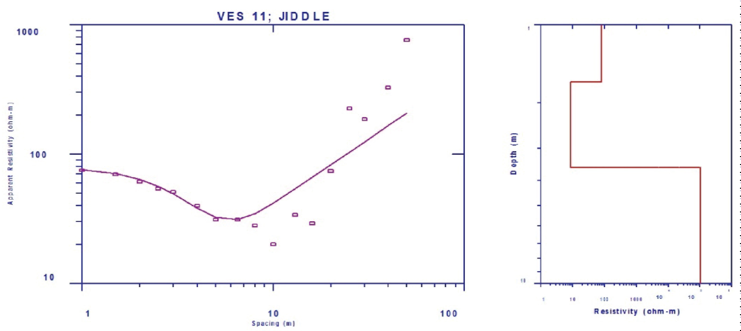
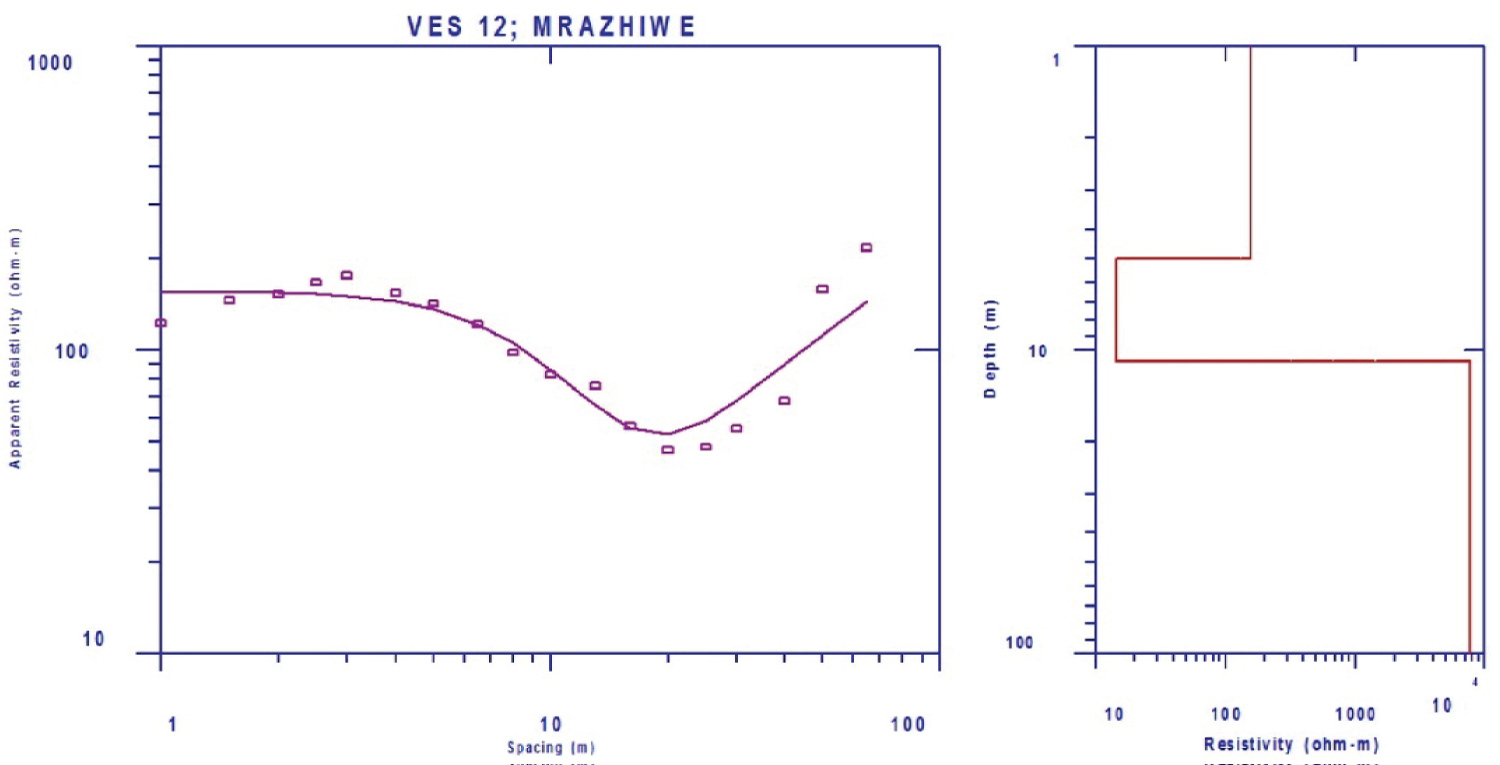
Resistivity field data was interpreted using software packages that give the output in the form of the number of subsurface layers, their true resistivity values, thickness and depth from the surface. A computer software program Interpex 1-D (IX1D) was used to interpret the data collected in this study. This package is capable of converting the values of apparent resistivity as function of electrode spacing acquired as the field data to values of true resistivity as function of depth of individual layer for the actual condition in the ground to be interpreted. It smoothens the field curve through the process of filtering technique that involves single point correction, eccentricity correction and vertical curve segment shift [22]. The vertical electrical sounding (VES) data are presented as depth sounding curve, which are obtained by plotting apparent resistivity values against half-current electrode spacing on a log-log or bi-log graph paper. The depth sounding curves are presented in Figure 3a, Figure 3b, Figure 3c, Figure 3d, Figure 3e, Figure 3f, Figure 3g, Figure 3h, Figure 3i, Figure 3j, Figure 3k and Figure 3l.
The curves obtained from the present study are type-H and type-Q. The type-Hcurve is the most predominant curve in the study area, which is typical of a basement crystalline rock environment containing a low resistivity intermediate layer underlain and overlain by more resistant materials. In basement terrain, the intermediate layer of the type-H is usually either weathered or fractured and is commonly water saturated which is often characterized by low resistivity, high porosity, low specific yield and low permeability [23]. The weathered and fractured layer constitutes the hydrogeologically significant layer because of its water bearing capacity. The extent to which the rocks have been weathered or fractured determines the amount of water to be found and these in turn govern the electrical resistivity values. The thicker the overburden, the more viable the groundwater exploration becomes in such environment. In another case, fractured bedrock has been the most promising factor for groundwater exploration in crystalline terrain [24-26]. The lithologies of the subsurface were inferred from the geoelectric sections bearing in mind the surface and subsurface geology obtained from nearby boreholes and wells. The inferred lithologies in the study area from top to bottom is three layers which includes the combinations of the following: Sandstone, overburden soil, laterite, clay soil, weathered basement rock and fresh compacted basement rock as presented in Table 1.
The first geologic layer is predominantly made up of topsoil with a resistivity value that varies from 30 to 40 ohm-m and thickness range of 0.2 and 5.0 m. The second layer is made up of Sandstone with resistivity value that ranges from 8 to 50 ohm-m and a thickness of 7.0 to 28.0 m, Clay soil was observed at two VES points with resistivity value of 1.8 and 3.6 ohm-m and thickness of 4 and 1.2 m respectively. The third layer comprise of the weathered and fresh basement. The weathered layer resistivity varies from 31 to 230 ohm-m while the fresh basement has a resistivity value greater than 1000 ohm-m.
Groundwater potential was evaluated based on the thickness of the overburden, the thickness and the resistivity of the weathered layers.
Conclusion
Resistivity survey was conducted in Michika Local Government area with the aim of investigating groundwater resources utilizing the Schlumberger electrode array in order to identify suitable site for borehole. A total of twelve (12) vertical electrical sounding (VES) locations were probed in the study area and result interpreted gives an overview of the aquifers that are present in the area with their thicknesses.
The interpreted data revealed two types of aquifers in the study area; the weathered basement and sandstones formation. VES 01, 02, 05, 06 and 07 has the weathered basement as their aquifer, while VES 03, 08, 09, 11 and 12 are made up of sandstones aquifer. VES 04 and 10 have clay layers as aquitard at their locations. The aquifers in the study area are suitable for hand dug wells and boreholes depending on their thicknesses.